GIS Mapping and Spatial Data Analysis Course

Posted By : User Ref No: WURUR71736 0
  • Image
  • TypeTraining or Development Class
  • Image
  • Location Westland Nairobi Kenya, Nairobi, Kenya
  • Price
  • Date 01-02-2021 - 05-02-2021
GIS Mapping and Spatial Data Analysis Course, Westland Nairobi Kenya, Nairobi, Kenya
Training or Development Class Title
GIS Mapping and Spatial Data Analysis Course
Event Type
Training or Development Class
Training or Development Class Date
01-02-2021 to 05-02-2021
Location
Westland Nairobi Kenya, Nairobi, Kenya
Organization Name / Organize By
Upskill Development Center
Organizing/Related Departments
Upskill Training Department
Organization Type
Organization
Training or Development ClassCategory
Both (Technical & Non Technical)
Training or Development ClassLevel
All (State/Province/Region, National & International)
Related Industries

Education/Teaching/Training/Development

Engineering

Research/Science

Agriculture/Agribusiness

Fresher/Trainee/Professionals

Location
Westland Nairobi Kenya, Nairobi, Kenya

Introduction

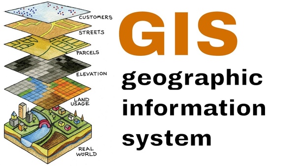
Geographic information systems are used in infrastructure management, project beneficiary mapping, service facilities mapping, land use planning, market analysis, impact analysis and utilities management.

Geographical information Systems have become an essential tool for planning, resource management and decision making. The ability of GIS to store, retrieve, analyze model and map spatial data has enhanced its application.

This course aims at equipping the learners with knowledge to use GIS tools to visualize real world features, explore spatial data and analyze maps to communicate information and make decisions.


Who Should Attend?

This training is designed for participants who want to apply GIS in the work to share information and make decisions.


No of Days

5 Days


Course Objectives

  • Perform spatial analysis to better understand your data
  • Create and share online maps using web GIS platforms
  • Acquire, clean, and map GIS data
  • Geocode addresses to longitude and latitude coordinates
  • Work with attributes and shapefiles in map making
  • Work with both vector and raster data
  • Complete an entire GIS project on acquiring, processing, analyzing, and visualizing GIS data.
  • Perform joins, clipping, normalization, and many more core GIS operations
  • Work with vector and raster data

Course Content

Click on this link to view course content

Registration Fees
Available
Registration Fees Details
Online Training Fee USD 600, Classroom Training Fee USD 1000
Registration Ways
Email
Phone
Website
Address/Venue
  Upskill Training Center, Nairobi Kenya  Pin/Zip Code : 00100
Landmark
PrideIn Hotel, Westland Nairobi
Official Email ID
Contact
Danson Mwaniki

[email protected]

   +254721331808
SI NO Filename Download
1 Document Download